Monday 16 May 2022

When did Christian services start in Tellicherry and its Fort?

Figure 1, St John's Church, Thalassery in 2009.
  Photo courtesy Jissu Jacob


Who built St John's Church at Thalassery?

It is widely believed by many that it was Edward Brennan, the Harbour Master at Tellicherry during the 1860's. This "fact" appears in countless websites, tourist guides, etc. etc. but I believe masks a much earlier series of places of worship on the site.

While it is true that Brennan rebuilt the church in the 1860's, his was definitely not the first church at Tellicherry.

Figure 2. Edward Brennen's memorial plaque
 inside St. John's Church, Thalassery

There are several different Christian Churches in Thalassery today. Each one represents a different form of Christianity, Catholic, C.S.I Protestant, & Basle Mission. All make claims for their foundation dates that are at best questionable, and at worse incorrect.

St. John's Church besides the fort is a Protestant Church. The formal state religion of England had been the Protestant one from the days of King Henry VIII in the 1530's. There were short periods in English history when the Catholic Religion returned during the reigns of Queen Mary I, and King James II, but these were short lived, and most English & Scottish officials will have been Protestant at home before they left for India.

In settlements under the East India Company rule, the official garrison church was therefore always a Protestant Church.  However the East India Company always struggled to recruit enough Protestant men to fill its military units, so that in practise there were often large numbers of Indo-Portuguese, Irish & English Catholics serving in these settlements as soldiers and as lower ranking officials.  These Catholics were accommodated by Catholic Churches, as was the case at Tellicherry, where St Joseph's Catholic Church was built besides the Protestant Church, both within the outer defensive walls of the fort at Tellicherry that we can all visit today.

One of the best preserved monuments & grave stones is that erected (as it would have originally have been set into the ground vertically, is that of Captain Gaspar Moritz Gleetz 1730-1768.

Figure 3. Captain Gaspar Moritz Gleetz 1730-1768

During the middle of the 18th Century there was huge disruption in Germany caused by the many wars that were taking place there. Germany was not a single country, but was dozens of often mutually antagonistic states. Parts of Germany like Hanover were ruled by the King's of England, who ruled both states.  Many German's became full time professional soldiers and officers.

When the British government was mobilising for each new war on Continental Europe, it would need to conscript tens of thousands of often unwilling English, Scots & Irish.  These huge recruiting drives increased competition for the available men in the community.  

Very often a ban was placed on the EIC in London to stop them recruiting in competition with the British Army, and this forced the EIC to recruit in Germany. They had recruiting agents who travelled into Germany, often up the Rivers Rhine, Elbe and Oder in an attempt to find suitable recruits. They were in competition with similar agents acting on behalf of the Dutch VOC, army & navy, who had similar issues finding enough men to fill their armies both in India, the Spice Islands as well as in Europe

Quedlinburg, where Gaspar came from is a town situated just north of the Harz Mountains in Germany mid way between Hanover & Leipzig. At this period many of the officers in the East India Company infantry companies came from Europe where they had often gained extensive experience during the wars in that part of the World.

Figure 4. Childhood home of Gaspar Moritz Gleetz

Modern sources all suggest that Harbour Master Edward Brennan had St John's Church built in the 1860's. This however cannot have been the case as there was a previous church on the site before 1820, constructed by the Reverend Francis Spring, which had been built over the alignment of an earlier wall that encircled the fort facing towards the sea, which had formed part of the defences to the Fort. The fill on either side of the wall had not been adequately compacted on either side of the foundations of the old wall, so that the earlier church broke its back over the old wall, some years before Edward Brennan funded the construction of the current church. 


Figure 5. Location map for Quedlinburg, Gaspar Gleetz home town. The survival of the early gravestone for Gleetz in the graveyard which was set up in 1768 suggests that this area was already consecrated ground by 1768, and possibly much earlier, and that worship was going on close by.

Life expectancy for new arrivals in India during the 18th Century was often less than three years, although those who survived the first three years could stretch to a further twenty years or more in India. Less than 30% of those who arrived from Europe could expect to return there. This means that at least 70% are buried in Tellicherry or nearby.  Somewhere around 10 new people would arrive from Europe each year, sometimes it was more, at other times less. In some other EIC forts like Fort St David, it is known that in the absence of a church, the Gunner's Room was used as a makeshift chapel on the relatively rare occasions that a parson was passing through the settlement or arrived as a chaplain on a passing East India Company ship. Some EIC officers will have taken services  for their men too.

Figure 6. Tellicherry Fort during the latter part of the 1720's preserved at the British Library. The painting was by Samuel Scott, and was one of a number of official paintings done in London which were hung on the walls of the EIC headquarters in Leadenhall Street. Scott had not been out to India, but must have been working from drawings made by an officer on board a visiting East India Company ship. 

Notice the large buildings inside the fort, which have subsequently disappeared. Notice also that there are a number of garden terrace or defensive walls between the fort wall and the sea, in the area where St. John's Church currently stands. It was one of these walls that the Rev. Spring's 1820's church broke its back over. 

The East India Company who arrived at Tellicherry in 1699, were taking over an earlier French settlement that was founded in about 1677 in the area that is now covered by the central bazaar, would have been very wary of worshipping in public, for fear of upsetting the religious sensibilities of both the Hindu's and Muslims.

This concern about Indian objections to Christian religion being outwardly conducted was a very serious, so that the EIC Directors in London made a considerable effort to stop missionaries and clergymen from going out to India.  This policy remained officially in place until the 1830's.

This policy was often deeply unpopular with many of the EIC officials and men who would have attended church services once a week on Sunday every week of their lives. Many will have lived in homes were the head of the family had a bible, and would say family prayers every evening for his family and his servants. 

With death & illness an ever present threat in Tellicherry, many men, especially those who were ill and were close to death will have been very concerned that there was no clergyman to administer to their needs or to administer the Last Rights. Men who were probably not very religious throughout most of their adult life, would suddenly become desperately anxious to be blessed, as it was firmly believed that they would not otherwise get into Heaven.

Christening were not possible, and marriages could not be formally solemnised.

The EIC local employees were however able to get around the official EIC ban or restrictions on clergymen. All along the Malabar coast there were many ports belonging to other countries, or native states, and these ports often had entirely different policies on the presence of priests or parsons in their settlements. Most of these parsons came from Protestant states in Germany, just like Gleetz had. Although they were employed by either the Dutch or English companies, many of these soldiers & parsons were not Dutch or English, but ethnic Germans. 

From time to time one of these Dutch / German missionaries would be invited to Tellicherry were they would give services which the garrison and merchants would attend.

Gunner's were a separate part of the military garrison, and they considered themselves superior to the infantry. They received higher pay, and their NCO's were allowed to distill Arrack which they could retail to the visiting crews of EIC ships anchored in the bay.

They had their own room inside the Fort. The gunners were never expected to leave the settlement, having to live next to the all important cannon, on whose effectiveness the survival of the settlement depended, unlike the infantry who could be sent elsewhere. The gunners barrack rooms were generally much better quality than those allocated to the infantry.  

It is known that at the same period, in other forts like Fort St David's were my 5 x great grandfather Captain John De Morgan (a French Huguenot, who served in the EIC garrison at Fort St David from 1711 until 1746), that officers like De Morgan would hold weekly services for their men inside the Gun Room, in much the same way that Royal Navy officers often do to this day in the absence of a chaplain. 

Figure 7. Captain John Sibbald of the 34th Regiment who died in December 1843 

By the 1780's with the preaching of men like John Wesley, the Established Protestant Church began to reform itself.  It did however split as a result, in the officially recognised church and into the Non-Conformist churches like John Wesley's Methodist Church.  The increased competition from the newer churches caused the Established Anglican Church to have to reform itself, and to reinject itself with new energy.  One of the effects of this reconfiguration of the church in England was renewed pressure on the EIC Directors to allow missionaries and clergy to officially travel out to India directly in EIC shipping. The Reverend Francis Spring was one of the first of these early "official" Anglican Protestant missionaries from this new generation of active and dedicated missionaries and clergy.

Spring was sent to Tellicherry and later on to Cannanore where he played an important role in establishing both of the St. John's churches in those locations. 

Up until about 1812 a substantial garrison had existed in both Tellicherry and Cannanore. By 1815 it appears that a decision was taken to move the army out of Tellicherry to Cannanore, where the existing site and fortifications could more easily accommodate the garrisons and prisons required.

However, the judicial community that was living in large comfortable house that they had built or acquired in Tellicherry were very reluctant to follow the garrison to Cannanore. It is believed that only about seven judicial officials remained in the town plus the harbour master by 1818.

We believe that Spring had arrived in Tellicherry in about 1817, and that he set about building a new church on the site of the former much older (1720?) garrison graveyard. This was to replace the old "Gun Room."  As Tellicherry was rapidly emptying of the churches potential source of a congregation, the raising of funds and the construction of the church may have taken a while, and the work may have been carried out in a less than competent manner. This may account for the fragile nature of the structure.

At the mean time the garrison at Cannanore probably numbered in excess of 500 European men, and needed a church of its own. The Rev. Spring became involved in promoting that church as well.

Spring himself appears to have left both Cannanore & Tellicherry during 1823 heading home to England. Responsibility for his churches was transferred to the Church Missionary Society [CMS], who subsequently supplied funding an clergy from England. Some of their reports are now available online dating from the 1820's, and I will explore those in later posts. 

As many of you are aware I have had an interest in the Thalassery and surrounding districts including the Wayanad for many years, and this has led to my becoming a focal point of contact for many other people who have similar connections with the town and the surrounding areas. 

Over the years these people have included former sepoys, teachers, bakers of the famous Victoria sponge cake, Mappila merchants, temple authorities as well as the descendants of former EIC officials and army personnel who served there over the years. 

Recently I have become involved in an informal project locally to try to improve the condition of several of local heritage sites in the town, which is succeeding in drawing a much greater of level of interest in Thalassery & internationally has been much than I had originally been expecting. 

 As I was taught at school, Brutus said to Cassius in Shakespeare's 'Julius Caesar' 

“There is a tide in the affairs of men. Which, taken at the flood, leads on to fortune” 

Whilst I have not been a great fan of Shakespeare since I left school,that quotation has remained a very effective maxim to deploy in my subsequent life. I want to see if I can build on the momentum that people like Biju Thomas have been very successfully building up locally, especially as I have been getting a lot of very positive responses from the local community in Thalassery. 

I am trying to get into a position to hold a series of launch events in the autumn of this year, or January 2023, when I hope to be in the town for several weeks, working on my own research projects.
Figure 8. Catherine Maitland, wife of John Vaughan 1833.

Vaughan was the Principle Collector at Tellicherry throughout most of the 1820's and 1830's.

 Figure 9. A close up of the plaque on Catherine Maitland's tomb.
                               
One of the key sites that can be visited today is the former Protestant garrison church at St John’s Tellicherry. This church is sandwiched between the old East India Company Fort and the sea. When I was last in Tellicherry in 2006, it was in an appalling state.

Fortunately, in 2009 the local church and community authorities undertook a very thorough restoration of the structure of the church itself. This work is described in the following two blog posts that I made in 2009.

http://malabardays.blogspot.com/.../tellicherry-church...
and
http://malabardays.blogspot.com/.../tellicherry-church...

Since 2009 the church has had a number of further restoration efforts made, and the grounds have been maintained periodically.

Figure 10. Cecilia Lawrie's Tomb

The numbering on the tombs in red had been applied to many of the monuments and grave stones by 2009. The highest number that I am aware of is about 50, but the person who took this photo told me that he believed that there had been far more gravestones in the graveyard orginially, but that only the most robust ones had been numbered.


Figure 11. St John's Church under restoration in 2007.
Photo by Lindsay Gething.

The next door school, St Joseph's Higher Secondary School, Thalassery which has origins as an Anglo-Indian school going back to the 18th century, and which is run under the management of Latin Diocese of Kannur, has taken an interest in St John’s Church which is located in the heart of the town of Thalassery beside the original Tellicherry Fort.

The Bishop of CSI church for North Kerala Diocese has recently expressed his interest in the project and wishes to talk about how to ready the British Heritage assets in his churches for the proposed north Kerala tourism development in a way that would be helpful to the society and his community Members. Depending on the response from interested parties, we might try to develop a process to roll out our project to encompass other nearby churchyards from other denominations. If you have connections with Tellicherry or have ancestors buried in these churches, and feel that you might like to take part please email me at balmer.nicholas@gmail.com

Figure 12. Eliza Wills, wife of Henry Crewe
who died at Tellicherry in 1874


At present I have no knowledge of Henry Crewe's life. Does anybody know anything about him?
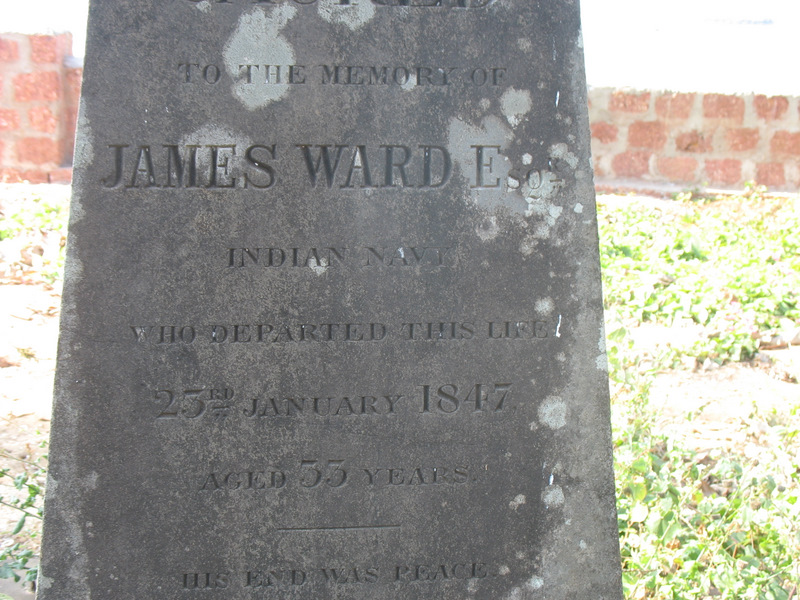
Figure 13. James Ward Esq, Indian Navy

It is hard to be certain which part of the Ward family this man came from.  There are several references to a Lieut. Ward in "The History of the Indian Navy 1613-1863" by C. R. Low, which suggest that Lieut. Ward had spent a lot of time as a marine surveyor in the Bombay Marine off Socotra and Aden at the mouth of the Red Sea.  Surveying the shores of the Indian Ocean was a very important part of the work of the Indian Navy at that time.

As they approached retirement age, many former Indian Navy officers left their ship based activities for shore based posts and became Harbour Masters, so it is entirely possible that he was Harbour Master at Tellicherry at some point between Mr. Oakes and Mr. Brennen who were also Harbour Masters at Tellicherry.  C.R. Low also mentions a Lieutenant C.Y. Ward, who compiled the "Gulf of Aden Pilot" published by the Admiralty in 1863. He might be either James Ward's brother or even son.

Many people who had become seriously ill in other parts of India or the Indian Ocean, made sea voyages to Tellicherry from places like Bombay. The voyage alone was believed to be good for you, and was often prescribed by Company Doctors, and the voyage often cured many illnesses.  Tellicherry had been seen for many years as being a particularly healthy station compared with most other coastal EIC port settlements.

As Ootacamund developed into a summer hill station by the 1840's, many people from places like Bombay who were already ill travelled via Tellicherry or Cannanore to Ootacamund via the Wayanad, and their letters and diaries often contain some of the best descriptions of the Tellicherry area at that time. It is possible that James Ward had been passing through Tellicherry when he died.

Figure 14. A close up shot of the inscription on James Ward's monument

Like so many children, Elizabeth Schmidt had died aged just 10 months and 15 days old in 1822. One can only imagine the heart ache at this gravestone for her parents.


Figure 15. Elizabeth Frances Schmidt.  Schmidt is a German name that means smith.

Many earlier tomb stones have probably crumbled or been pushed aside in recent years.

Figure 16. James Crawford (possibly). 
He may have been related to Mr H Crawford who was Commercial Agent
 for the Travancore Government at Alleppey


Figure 17. James Stevens, who was the senior judge
 at Tellicherry in the early 1800's.

James Stevens played a very important role in leading the establishment of EIC law the former local rulers estates in the aftermath of Tipu Sultan's invasions. Under huge pressure to deliver, inadequate numbers of staff and with the Pazhassi Rebellion under way at the time it must have been a tough assignment. My 4 x great uncle Thomas Hervey Baber was 3rd Judge at the same time that Stevens was 1st Judge. They were of very different generations and mindsets. They did not get on very well at times.

Figure 18. James Stevens grave monument.

James Stevens modern descendants live in Australia, some of them visited this tomb about a decade ago. The dark stain was caused by the use of water to try to make the text readable. It will have dried away shortly afterwards.  You can see how the heavy rains and sun are taking the toll of the chunam plaster exposing the laterite blockwork underneath.

Figure 19. Margaret Eleanor John, who was born in 1837 and died in 1911.


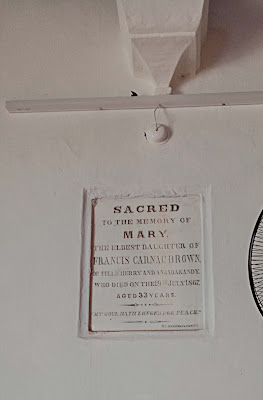
Figure 20. Mary Brown, daughter of Francis Carnac Brown. This photo dates from quite recently, and shows how it was over painted in recent years.

Mary Brown's grandfather Murdoch Brown had been a really colourful character whose life would make a good film or novel. He bought a lot of slaves at Alleppey from local slave dealers, for use to cultivate his new plantation at nearby Anjarakandy. 

Figure 21. This was Mary Brown's plaque a few years earlier.
It is a great pity that it was painted over. I wonder if the paint could be removed?


By seeking to use slave labour in 1797, Murdoch Brown was following centuries old, local custom and practice. 

Thomas Baber who had only relatively recently arrived from England where he appears to have absorbed the early campaigns of anti-slavery campaigners of the Clapham Sect. He went on to take out a private prosecution against Brown in the Madras High court. 

Brown organised for an army officer (with a severe debt problem, and a reputation for fighting duels to try to pay off his crippling debt.) called Billy Robinson to challenge Baber to a duel that was fought.

As a young officer Francis Carnac Brown also challenged Baber to a duel a couple of years later. Brown and his two accomplices were prosecuted, again privately in Madras, and to the disgust of many in court Thomas Baber secured a successful prosecution, sending Brown and the other two to prison.

Francis Carnac Brown seems to have quickly recovered from his time in prison, and as an older and no doubt wiser man, he went on to play a major role in establishing planting in the Wayanad and elsewhere. He wrote several really interesting books on planting & other issues facing EIC expats in late 1830's Kerala.

One can only imagine what the scene was like in this church with the Brown family sat in one pew and the Baber family nearby in another pew.

Figure 22. Patrick Henry Gordon who died in 1876. A planter, Patrick appears to have made it back to Acton to the west of London, where he died and was buried in Kensal Green Cemetery.  It is evident that his former fellow planters regarded him highly enough to put up a plaque in St John's Church.

Does anybody know where Polly Coon was in Tellicherry?

Figure 23. St John's Church Tellicherry in 2006-2007

This was the state of St John's Church when I visited in in 2006. At that time I though that the church was probably beyond recall.

The growth of scrub in the grave yard was chest high when I climbed into the grave yard. The place was full of mongooses, and my dear local host was beseeching me to get out of the graveyard as fast as possible, as it must be full of snakes to be able to support so many mongooses.

Thankfully the community at Thalassery have taken substantial steps to look after this church in recent years, and they should be thanked for having done so much to preserve this part of our shared heritage.

Especial thanks are due to Dr. Denny, the Principle, and the pupils of St. Joseph's Higher Secondary School who are looking after the graveyard currently.

Figure 24. Here is one of the other tombs but sadly the inscription is not readily seen in this photo.
The church under restoration in 2009 can be seen in the background.
Note the amount of rubble from tumbled down tombs lying around.


Tuesday 25 August 2020

Was the Pazhassi Raja Set Up? Part 2.

At the end of the war in 1792 the EIC administration had set up the Malabar Commission to reach a Revenue Agreement with the local Raja’s. The Pazhassi Raja felt that the EIC had not treated him fairly in this agreement and that he was not receiving a sufficiently high share of the Revenues.

 From Extract Political Letter from Bombay 18th December 1796. “By subsequent advices from the commissioners, dated the 23rd of August, we received a Copy of Colonel Dow’s Report of his Deputation into Wynaad, containing very interesting information relative to the former circumstances of the country, and conveying his ideas, as to the political importance of it. The colonel commences by observing that the Wynaad, when viewed merely as an object of Revenue, appears to be inferior. Consequences as that Territory, as well as the Possessions above the Ghauts, in general, had been laid waste, and depopulated, and must therefore require a continued state of tranquillity and careful management, before any considerable supplies could be drawn from them, but that abounding in a fertile soil, and producing several Articles Valuable in Commerce, they would in course of time become ample Funds of Wealth.”

The report goes on to record that Col. Doveton, who had escorted Tipu Sahib following his defeat in 1791, had written that: - “Tippoo had received 90,000 Rupees in revenues from the Wynaad” (before 1791.)

 The Raja Koorminaad had collected the Wayanad’s Revenue after Tipu’s retreat, and quite possibly whilst Tipu had controlled the area: - “for which he must of course have been accountable to our Government.” In 1791 “Tippoo withdrew his Troops from the District in question, and established his advanced Post at Intacotta, which being situated on the borders of our Territory became his proper Frontier.”

 The Political Letter then goes on to describe events in 1792. ““That during the war, the People of the [Pyche] Raja seized on the Wynaad as part of their ancient Territory and were at the Peace in possession” and the lasted quoted address to Bombay of June 1792 continues to state “That on the 6th of May 1792 a message arrived from Tellicherry from the Raja of Cotiote, stating that an officer from Tippoo had sent to the person in charge of Wynaad to deliver it up as the right of Tippoo and that similar letters had been sent by the same person to the Raja making the same demand.” Mr. Farmer not having then left Tellicherry, the Chief and Factor requested his ideas and directions on the subject, when he advised that the Raja should instantly send word, that the country being yielded to the English, he the Raja, could give no answer till he had informed the Chief of Tellicherry, but that, as Wynaad was certainly not including in the Grants of Tippoo, it could not consistently be retained, and that therefore the Raja must order the People to withdraw to the Boundaries of Wynaad, there taking a stand, and advising the Chief; if Tippoo’s people presumed to encroach beyond that boundary which the Bombay Commissioners then believed we had no claim to the Eastwards of, in so much that on the 9th of August they wrote to Tippoo’s Subahdar Hurry Purwae apprizing him “that as at the time mentioned by the Treaty we do not find Wynaad to have been under Calicut, we do not mean therefore to detain what was granted to the Company;"

Writing on 2nd March 1797. “the late untoward Events in one of the Northern Districts in the Malabar Province which it grieves me sorely, to have to relate, howsoever much they may appear to have primarily and in a great degree unavoidably flown, from the Rivalry and Dissentions between two Cousin Germane called the Raja’s of Coorimnad and Coltiote, the former progress and fortunate issue of which stand already narrated in the Revenue letter from this Presidency of the 18th of December last, as does their unexpected Renewal in my late address to the Secret Committee of the 12th of January of which a Duplicate is herewith sent—“ “2 You will Gentlemen already know from the first report of the Commissioners that all the Malabar Rajas feel and have indeed all along felt rather uneasy under the degree of Restraint and Submission that we have since the Peace with Tippoo Sultaun endeavoured to subject them to, among these none has been so turbulently impatient all along as the Raja of Cottiote, otherwise called for distinctions sake, and as being indeed his more proper designation the Pyche Raja, one of the members of the family of the Raja’s of that District who having during the late War with Tippoo remained in the Jungles when his other & Senior Relations fled for refuge to Travancore acquired thereby such a footing in the affections of the people, that even after his services returned at the Peace he maintained his influence, so as to have been considered by the first Joint Commissioners from Bengal and Bombay & Treated as the effective or at least the acting Raja, at the same time that, on his behalf & with his consent they settled most or all of what related to his District with the Raja of Coorimnad the son of his Mothers sister (all heirship amongst these Chieftains going in the female line) and who whom as his senior, he professed at all times the greatest deference so as to consider himself to be only the manager under his orders; but yet his conduct was on the whole so turbulent & refractory that in the year 1794 Mr. Stevens then the Supravisor concluded the five years settlement of the Coltiote District not with him but directly with the Coorimnad Raja his relation as being at the head of the house of Cottiote whereas there are several between him and the Pyche (By misnomer called by us the Cottiote Raja) in order of succession not withstanding which the Pyche Chieftain has ever since the conclusion of this quinquenial lease proved extremely restless and jealous that it became soon after my entering on my present charge a serious and pressing consideration how to proceed in regard to him, in as much as he forcibly prevented the Coorimnad’s making the Collections under the quinquennial lease, to such a degree that the latter declared he could not pretend to go on with them without a force of 5 or 600 men of our Troops, in view to all which and also to enable us in pursuance of a Recommendation to that effect, from the Bengal Government to bring him (the Pyche) to account for his conduct in having put some Mapillas of his own Authority to Death, the commanding officer on the coast / General Bowles) was not only instructed to afford the Coorimand Raja the necessary support – but it was left to the last mentioned commanding officer and to the acting Supravisor Mr Handley (comprising the Civil and Military Superior Authority on the spot) to consider whether it might not be advisable in view to saving effusion of Blood if the Pyche Raja’s person be secured so as to prevent his protracting an insurgency by betaking himself an insurgent to the Jungle."

The Rajah was able to harness the grievances of the peasant farmers, who felt that they were being over taxed, to his own. Together with the Raja, the peasants began attacking the British forces. Several battles took place, during which EIC officers and sepoys were killed. In 1797 a temporary peace was agreed with the Raja, but it broke down once again in 1799. Francis Buchanan who travelled through the region during 1800 and 1801 described the local conditions that were to play such an important role in Thomas Baber’s life over the coming years: - "January 1st 1801 – In the morning I went nine miles to Tamarachery. The country resembles that which I came through yesterday, but much of it is waste. At Tamarachery there was a house belonging to the Pychi Rajas; and as it was on the road to one of the principle passes leading up to Karnata, Tippoo established in its neighbourhood a strong colony of the ruffian Moplays; and until lately, a constant petty warfare has been continued between them and the Nairs."

The Moplays or Moplahs were a Muslim people who had lived in the area for 500 or more years, and were the descendants of Arab sailors and soldiers who had settled in the area. Francis Buchanan recorded that: - “under Hyder Hindus were tolerated, but under Tippoo Islam was the sole religion and the Moplays were brought to prominence."

During the Mysore War under Lord Cornwallis many Hindus were circumcised by force and others fled into the jungles to wage war on the Muslims. The descendants of the Rajah’s were invited to join the EIC armies and after the armies of Tippoo had left the Naires returned from exile in Travancore. The rebellions and unrest became so severe that the EIC took the administration of the Malabar Coast away from the Bombay Presidency and put it into the hands of the Madras Presidency in July 1800. A Major McLeod was appointed as Principal Collector of Malabar to try to reform the district. Thomas Baber was one of his assistants. McLeod introduce a new exchange rate for the local coinage in August 1802, and increased the revenue assessment. This left most of the peasants in arrears, which could only be recovered by force. The wars had badly affected the local economy. The production of pepper fell, as did the price of pepper in the market. With the capture of the nearby French and Dutch settlements there was no alternative market within which the farmers could dispose of their produce. The EIC could set the prices.  

William Ewer writing in 1797 offers us a short description of Mahé. "Mahe. This is a beautiful little place four miles from Tillicherry, taken from the French this war; & if possible it ought to be kept; it was at all Times; when in their Hands a place of Political Intrigue & gives them a footing in the Coast; it is a Residence of Foreign Merchants out of Controul of the Company who interfere very much with the Company's concerns. The Road to the southward is through it, be sides this; the French will always have it in their Power to create & encourage Disturbances amongst the Natives. "

 The British had taken over the tax assessments made under Tipu by Canarese Brahmans. These assessments were too high to be sustainable for the farmers when set against falling prices and production of crops. In a good year 8,000 Candies of rice could be grown in the Tellicherry area, of which 4,000 came from the Pyche Raja’s territory.

In 1800, the Raja’s crop had dropped to 2,500 Candies. The situation quickly became very tense. A later official William Logan described the state affairs had reached: - "The accounts were fabricated, actual produce was over assessed, produce was assessed that did not exist, and assessments were imposed on the wrong men".

When the EIC took over the province, they took over the existing revenue assessments. They also used many of the existing native revenue officials to carry out the collections. This caused considerable problems. Hyder and his officials had been fairly brutal in his methods of collecting taxation. With falling pepper prices the collection taxes at these levels of assessment was not sustainable. As was the case elsewhere in the native ruled provinces of India, the taxation was assessed at a high rate, and farmed out to local collectors.

Its collection was however usually often very inefficient and sporadic, so that the actual sums collected were often much smaller than the theoretical amounts available. Murdoch Brown a local planter explained the taxation situation to Francis Buchanan in 1800: "Mr Brown thought that prior to Hyder’s invasion the natives of Malabar had had reserves of precious metals etc. which Hyder extorted. He used Canarese Bra’hman’s to assess and extract the money. These reserves rapidly diminished partly because the Petty Raja’s connived with the Bra’hmans to hang onto the money."

Sunday 5 March 2017

Cannanore Fort, Part 2, & the Beebe of Arrakal


Figure 1. The former palace of the Bibi of Arrakal. [1]


One of the most interesting of the many Indian's who Thomas Baber came into contact with, and one who he evidently had a right regard for, was the Bibi of Arrakal, known today as the Arakkal Beevis.

"The old Beebe of Cananore having written a Petition the other day she wanted me to forward to you, but which I declined, not from any wish to with hold her Petition, but that it appeared more consistent with Propriety in her writing to you herself – Whether she has done so or not I know not, but if she has you will see her case (the Subject is her Lacadive Islands) fairly stated enough and will, I think agree with me that our faith has not been preserved to her – The Court of Directors under the idea that the Islanders were adverse to her Government, were of the opinion that it was not advisable to restore the possession of the Islands to her but that to the consideration in (money?) should be allowed her on account of them – nothing however can be so erroneous as the idea of the accession of the inhabitants to the Government, and it is but reasonable to approve that they would be far better treated by her than a Farmer or even Deputy, removed at such a distance from all control, I don’t know what the advantages are the Company at present derive from these islands, but when the Beebe says (which she has repeated to me) that she will pay the Company as much as ever they received from them, and will hold herself accountable to our Government or our Courts for all her acts, there can be no objection to restoring her to her rights – She has received no compensation, not withstanding the Court of Directors orders, -- Should you view the subject in the light I do, I shall be most happy to afford my personal aid in concluding with the Beebe, (or if necessary making a survey of the Islands themselves) any arrangement that would be most acceptable to Govt for, I am convinced the Old Lady would come into any terms to regain possession of her islands." [2]

Cannanore had been an important international trading port long before the Portuguese arrived off its shores.

A Muslim dynasty based at Cannanore had controlled much of the trade from the Northern Malabar Coast to the Gulf. Following the arrival of the Portuguese who tried to control the coastal trade, this same dynasty had helped to maintain the Indian Arab trade via its Laccadive homelands, circumventing the Portuguese naval blockade by adopting routes away from the Malabar coast.

This redoubtable family was traditionally led by a matriarch called the Beebee (or Bibi) of Arrakal. Although much diminished in status by Thomas Baber's time the Beebee was obviously highly regarded by Thomas, who tried to restore her rights and previous trading business.

The extent of the former trade carried on by the Beebee and her other Muslim trading partners is demonstrated by the following answers given in evidence by Thomas Baber to the House of Lords committee on the 31st March 1830.

When discussing Mopillas... he gave the following evidence when the following questions were posed to him by the members of the committee.

Therefore they invested the Fortunes they have had in Trade?

Yes.

Do they trade much with the Coast of Arabia?

Yes.

With the Persian Gulf?

Yes; with the Red Sea, especially Judda, Aden, Mecca, and Medina, and generally with all the Ports in the Red Sea.


Are their Vessels numerous?

They were; but they are not now Half what they were, in consequence of the Monopoly of Timber by the Government, who assumed and declared the Forests to be Royalties, instead of which, those in Malabar have been purchased or inherited in the same Way as every other Description of Landed Property.

Are they unable in consequence to build Vessels?

They were for some Years. I have seen several Applications, both to the Bombay and Madras Governments, requesting Permission to fell Timber themselves, or to purchase Timber of the original Proprietors; which Requests were invariably refused, on the Ground that the Timber was required for Naval Purposes.

Has it been used for such Purposes?

Yes, it has, to a great Extent: but a certain Portion has been sold, chiefly what is called the Refuse, or Second and Third Sorts.

What Description of Wood?

Chiefly Teak and Poon.

Who were the Purchasers of the Timber which was sold, which you call the Refuse Timber?
Arabs, Parsees, and occasionally some of the Inhabitants themselves.

What is the Size of the Vessels?

The Size of the Vessels was from One hundred to Five hundred Tons. I can mention the Names of some of the Ship Owners: the Beebee or Queen of Cananore. This Lady is Queen in her own Right.

How many Vessels has she?

She had previous to the Monopoly Nine; she has now Four or Five. Chowakkara Kunhy Packey, the Heir of old Moossa, a Man well known on the Western Coast, had Twelve; that is, Moossa himself had. These are reduced, I think, to Seven. I can mention their Names and Burthen.

What was the total Number of those Vessels?

At one Time, from Twenty to Thirty of from One hundred to Five hundred Tons Burthen, belonging to the above Two Persons and other Ship Owners; besides which there were other Descriptions of Vessels, such as Botillas, Dows, Dingeys, and Patamars and Munchoos.

Those smaller Vessels carried on the Coasting Trade?

Yes; and some of the largest of them go up to Mocha, Judda and other Places in the Red Sea; also to Muscat, Bushire and Bussora, in the Persian Gulf; Porabunder, Cambay, Cutch, Sind, and a long Way up the Indus.

To what Town on the Indus did those Vessels go; did they go to Hydrabad or Sind?
Yes; I believe they go up so far at least. I have seen Bales of Cashmere Shawls brought amongst the Return Cargoes.

Are you aware whether they have ascended the River of Punjab?

No; I am not aware of any Communication with the Punjab Rivers. They go up the Indus; but I am not aware of their going there further than that. I know that Peishwoor Merchants have come down in Sind Boats.

Trade to a considerable Extent is carried on to Shiccapore, is it not?
No, I am not aware of that.

What are the Articles which are exported in those Vessels to the Red Sea?

Pepper, Cardamums, Rice, Paddy, (or Rice in the Husk,) Grain of all Descriptions, Arrow Root, Ginger, Cocoa Nuts, Kopra, (Kernel of the Cocoa Nut,) Cocoa Nut Oil, and Coir, which is made from the Fibres of the Cocoa Nut. The Value of the Produce of the Cocoa Nut Tree alone, exported from the Western Coast, is supposed to be an Hundred Lacs of Rupees.

From what Ports do those Exportations chiefly take place?
From Cochin, Chowgaut, Panany, Tanore, Perperangady, Beypoor, Calicut or Kohicote, Quilandy, (which is a favourite Arab Port,) Kotah, Barragurry, Mahe, Tellicherry, Cananore, Cavai, Bekklum, Mangalore, Cundapore, Onore, Cumpty, Seedashagur, besides numerous intermediate Ports.

Is Quilandy a good Port?

Yes; there are more of the Arabs congregate there, and more Mosques, than in any other Port on the Coast. The Mopillas here are the fairest of all the Mohamedans.

Can Vessels of 700 Tons enter every one of those Ports?

They can approach as near as a Thousand Yards of the Shore with perfect Safety, nearly all along the Coast.

Are they safe in those Ports during the Monsoons?
No; the strongest Vessel that was ever built could not ride out a Malabar Monsoon. One or Two Attempts have been made within my Observation, but they were obliged to go off.

Where do they go to when they are obliged to go off?

To Bombay; some to Cochin, where there is a very fine River.

What are the chief Importations from the Red Sea?
Coffee, Dates, and Gold Dust; Almonds, Kissmisses, (dried Grapes,) Prunes, Gums, Drugs, Perfumes, Elephants Teeth. There are several others which I cannot call to Recollection at this Moment; but chiefly, however, they bring Specie, in Venetians or Sequins and Dollars.

Do you know how far up the Red Sea those Vessels go?
The full Extent of the Red Sea. Very few of the Malabar Vessels go up that length, but they have Agents or Commercial Dealings the whole Way to Suez.

How far do the Vessels go?

To Cosheir, I think.

Have you heard of their being frequently lost?

No; very rarely indeed.

What Time do they occupy in going and returning?

They generally go before the Monsoon, and return after the Monsoon; or rather from January to April, and return from the Beginning of August to January.

From what Part of the Coast of Arabia do the Arabs chiefly come?

Chiefly from Arabia Felix.

From any principal Port?

From Aden, Judda, Mocha and Muscat, and all the Ports at the Mouth of the Red Sea.

Is much Trade carried on with Muscat?

A great deal, particularly with the Port of Cochin.

Are you aware whether any great Difficulties were experienced by the Merchants who come down the Indus?

No, I am not aware of any. Pirates were common some Years ago, but they are all destroyed, I believe, now.

The Question applies to the Navigation of the Indus itself?

No, I am not aware of any Impediment. I have often talked to the Sind Merchants whom I have met with at Tellicherry, Calicut, and Mangalore, but I have never been apprized of any particular Difficulties.

What are the Returns from Sind?

Cotton Piece Goods are all I can call to Recollection just now, except Shawls; but chiefly Specie. I think they generally purchase their Return Cargo with Money, which is so valuable to them.
[3]

It is very sad that today the ancient palace that the Bibi inhabited and which she was almost certainly visited at by Thomas Baber is now empty and decaying.  A recent article about the palaces fate can be found here..
http://www.thehindu.com/life-and-style/article3509127.ece


[1] From http://xpsajeevk.blogspot.co.uk/p/about-me.html by Sajeev
[2]Taken from a much longer letter by Thomas Baber to Sir Thomas Munro on the 25th June 1817. OIOC Private Papers IOR:MSS. F151 / 43 folio 50 – 54. to Sir Thomas Munro.
[3]From: British History Online Source: Affairs of the East India Company: Minutes of evidence: 06 April 1830. House of Lords Journal Volume 62. URL: http://www.british-history.ac.uk/report.asp?compid=16423 Date: 22/08/2004

Cannanore, the Portuguese Fort Part 3.


Figure 1. Cananor Fort from Gaspar Correia’s Lendas da
Índia (mid-1500’s). National Archives (DGARQ), Lisbon (reproduced
from Correia 1975). North is to the left, right is south.[1]
(Please click on image for larger version.)

The drawing above comes from a book written by Gaspar Correia, who is believed to have travelled out to India in 1512, and to have subsequently returned to Portugal in 1529. He left Portugal once more for India, living out the balance of his life there until he died in 1563. It is not clear when the drawing was done. Some authorities believe that the drawing probably pre-dates 1550.

The most striking object in the drawing is the tall tower or keep that stands over the centre of the fort. This tower is essentially a Medieval keep of a form commonly used in Portugal and indeed Spain as well. It is designed to resist weapons like bows and arrows, but would not be suitable to withstand cannon fire.

This suggests that at the time when the tower was built the Portuguese believed that the possibility of an attack by cannon on the fort was low.

Cannon had been present in significant numbers at sieges in Europe since the 1450's. Although cannon had been in use in small numbers since the 1360's, the first really effective use of cannon against castles had been in France when in 1449 Jean and Gaspard Bureau had used a siege train to reduce sixty English held castles in Normandy within a single year of campaigning, bringing to an end the English colonies in France.

At the time that the Portuguese fort at Cannanore was being conceived, the techniques for the use of cannon to defeat castles had developed very rapidly, especially in Italy after 1494 when King Charles VIII of France who had equipped himself with a state of the art, highly mobile artillery train, and had been able to rapidly defeat the Italian armies.

This dramatic series of campaigns, which changed the balance of power in Italy led to a fundamental rethinking of the designs of fortifications, first in Italy where huge new forts surrounded with earthen banks and angled bastions beginning to be built, and then further afield.

Italian architect Antonio da Sangallo was one of the first of this new breed of military engineers.  Between 1492 and 1495 he added octagonal bastions to Castel Sant' Angelo in Rome to provide protection against cannon, whose stone balls could destroy high stone walls with ease. By 1500 many fortresses and towns across Italy, France and Spanish controlled Naples were receiving similarly designed new walls and bastions. [2]

The fort drawn by Correira appears at first glance to be medieval in style, however on closer inspection of the drawing the fort can be seen to have a number of strikingly new features, linked to the development of forts designed specifically for artillery.

For example, the drum shaped tower in the north east corner  is surprisingly squat for a medieval tower.

Indeed it could almost be taken for a circular bastion of the type that was often used by German cities when they first adapted their town defences to cannon.

It is interesting to try to compare the fort at Cannanore with other forts in Portugal or in its overseas possessions.

By 1415 the Portuguese had largely defeated the Moors in Portugal, and as a newly assertive country had acheived a balance of power with Spain.

Most of the wars fought between Portugal and Spain, before 1500 had taken place when artillery was of little real importance in warfare. So although there are lots of later artillery forts along the Iberian border, these cannot tell us much about the design of Cannanore's defences.

However, when the Portuguese had first arrived in India they had already had nearly 75 years of colonial experience behind them gained in North Africa and West Africa.  So I began extending the area of my search to Morocco, where I have begun to find examples of forts that are very similar in style to that shown in Correia's drawing of Cannanore.

It has proved possible to find several forts in Africa with details showing similarity to Cannanore.

The fort with the greatest similarity is Castelo do Mar at the former Portuguese colony called Safim located in Morocco, and which is called Safi today.

This colony is especially significant for our purposes because the Portuguese control of Safi was of a very limited duration between 1508, and 1541. This enables us to assign a sequence of dates to the features at Safi, and because very similar features are also present at Cananore, we can make an attempt to date the sequence the development of the Portuguese fort at Cananore.


 Figure 2. Castello do Mar, Safi, Morocco, showing a very similar
keep to the one shown by Correia at Cananore. [3]

A number of modern authors including André Teixeira [4] and Martin Elbl suggest that the Portuguese typically built their forts in Africa and India over a number of phases, with the first stage being the very rapid construction of a rudimentary fort to secure their position, followed by subsequent upgrades and expansions.

This pattern of development appears to be borne out by the development of the Cannanore settlement and fort.

The very first Portuguese "fort" at Cannanore was built in November 1502. Da Gama had failed establish a trading post in Calicut, which was the best location for trade on the Malabar Coast at that time. Forced by Moor hostility to avoid Calicut he tried trading with Cochin next, where he was able to obtain pepper, before returning to Cannanore, which was also hostile to Calicut.

In order to lighten his ships before the long journey back to Lisbon, he decided to negotiate with the Kolattiri Raja to leave many of his ships cannon at Cannanore. Agreement was reached that the cannon could be buried, and the store would be surrounded by a security palisade and a door fitted with a padlock.  The key of which was keep at night by the Raja. Two hundred Portuguese were left behind when Da Gama left on the 28th December 1502. It doesn't appear that the enclosure was used for accommodation, and one must presume that the Portuguese went to live in the nearby Mopila town along the beach to the east.

It is not clear where this first stockade was, and it may not have been located on the site of the current fort at Cannanore.

In September 1503 Don Francisco de Albuquerque arrived with a new fleet at Cochin, and soon began to construct a fort out of coconut tree trunks and earth to protect his settlement and his local ally, the Rajah of Cochin better against the serious hostility of the Zamorin. This fort was the first fort built by the Portuguese in India.

The next major fleet to arrive was that led by Don Francisco de Almeyda which arrived off the coast of India in September 1505 in eight ships. He had set out from Lisbon with twenty two ships and 1500 troops on board, but many ships were lost or delayed along the way. Almeyda had been issued with instructions dated 25th March 1505 specifically tasking him with building four forts at Anjediva Island, Cannanore, Cochin and Quilon.

He left a party at Anjediva on the 13th of September to start work a fort there, and then left for Cannanore, arriving on the 23rd October 1505, where he disembarked Lorenzo de Brito with 150 men and two ships to commence work on the fort, which he named St. Angelo.

It is not clear what the first fort that was besieged by the Raja of Cannanore and successfully defended by the Portuguese from 27th April 1507 for a period of four months looked like, or it's exact extent. [5]

However, there is a vital clue arising from events during the siege.

During the course of this first siege it had been discovered that the original design of the fort had been deeply flawed.  The only place that the water supply for the fort could be obtained was from a well located outside the walls of the fort on the side occupied by the attacking forces. 

I believe that this original wall was probably aligned along the line of the wall shown to the south (right) of the keep or tall tower in Figure 3 below.


Figure 3. The suggested extent of "fort" built by Lorenzo de Brito
in 1505.

When Lorenzo de Brito was building the fort, it was as an ally of the local ruler, and it is quite possible that it was being built at a trading post, rather than as a full scale fort. The most important thing was to be ready to defend themselves as quickly as possible, and at this first period the most likely enemy was the Zamorin.

By walling off the headland they protected themselves with the minimum of effort. The most likely route that the Zamorin would arrive by was from would be by sea from the south.

In the second stage in the development of forts proposed by Elbl the forts were consolidated and permanent defences were built. I believe this second stage included the construction of the keep and its associated wall immediately to the north of the keep. The tower may have been built to dominate both the entrance door as well as the well which was now securely inside the new wall.[6]

It is not possible to date the keep or tower at Cannanore exactly, but it was almost certainly built immediately after the 1507 siege.

It is interesting to compare the keep at Cannanore with the keep constructed at Castelo Do Mar at Safim in Morocco on the western seaboard of North Africa in about 1512, which is very similar in construction, and this enables us to picture what the tower at Cananore must have looked like, and how it functioned.


Figure 4. Safi Fort from Google Earth showing both the keep tower
and early drum towers fitted for artillery along the southern
elevation.

One significant difference between the circular towers at Safim, which were built shortly after 1508, and those at Cannanore are their respective diameters and construction.  The towers at Safim appear to be taller, and to have rooftop positions, and to have been of a  smaller in diameter than those built at Cannanore. This suggests that the Castelo do Mar towers pre-date the Cananore ones.

I believe that the towers were constructed because although the defenders intended using handguns or small cannon to defend the fort, that these were still small hand held, or tripod mounted weapons.  Notice how the towers in Figure 5 have embrasures set into their walls from which cannon can fire both away from the walls, but also in some cases along the base of the walls.


Figure 5. Towers along the southern face of Castelo do Mar, Safim.
Note the letter box apertures installed for handguns or small cannons. [7]

The towers at Safim are approximately 9 metres across the top of the fighting platform, and were probably equipped with breech loading cannon like the one below.  


Figure 6.  Wrought iron breech-loading swivel gun with reinforcing bands around the barrel, cast in Portugal, circa 16th century. [8]

It is probable that the earliest cannon used in the forts at Safim and at Cannanore were taken from ships, and that they were therefore relatively small.


Figure 6. The area of second phase construction after 1507, marked in red.
Note the polygonal gun tower at the shore. 

Because it is not possible to attribute exact dates to the various drawings and maps that survive showing Cannanore, it is not possible to prove an exact sequence to the maps.

However, a valuable clue to the dates of these plans exists, when Figure 6 and Figure 7 are compared. Figure 7, fails to include the polygonal tower. Therefore it is probably earlier than figure 6.


Figure 7.  Another edition of Antonio Bocarro map from the Livro das fortalezas,
showing Cananore at an earlier period without the polygonal tower.  The earlier largely Muslim trading settlement belonging to the Bibi's of Arrakal can be seen across the bay.

The Polygonal Tower is again significant, because it offers another parallel with a polygonal tower at Safi, which helps to date the Correira drawing.

Safi has two fortified areas, the Castelo do Mar on the seashore, and a larger walled town on top of a nearby hill. The Portuguese were able to capture this Arab town, and they proceeded to fortify it in turn.


Figure 8. A photo showing the Polygonal Tower on the southern face
of the walls surrounding Safim town [9]

This polygonal tower at Safim must have been built before the town was lost by the Portuguese in 1541, and it is very likely that it was built to reinforce the earlier walls that had earlier circular towers. The Moroccan forces had by the 1520's acquired considerable numbers of cannon, and the weaknesses of circular and square towers with their concealed zones were becoming apparent. 

Figure 9.  A diagram from "Firearms and Fortifications" by Simon Pepper and
Nicholas Adams, illustrating the way that both round towers and square towers
have areas (hatched) at their bases which are unable to be covered  by fire
 from their adjacent walls. [10]

It is possible that this polygonal tower was an attempt by the Portuguese to address the weaknesses of the round towers with their covered zones, that they had previously been building.  The covered areas at the bases of these towers would have enabled besiegers to get into cover at the base of towers, where they could shelter from fire and from where they could start to undermine the bases of the towers. The use of polygonal towers, perhaps demonstrates the comparative isolation of Portugal from events in Italy where the angled bastion was being developed at around this time, and which would prove to be the most effective form of artillery defence for the next two centuries.

From Figure 7 above it is possible to see that the polygonal tower was added after the outer wall had previously been built with it's three semi circular towers. So it is likely to date not much later than 1540 to 1545, but it was built after the three cannon bastions were added.  When were these three semi-circular bastions and the outer wall built?

Again, it is not entirely possible to be sure.

Elbl writes that the Portuguese forts in Morocco first came under serious attack by cannon in the 1520's when the Sa'dians began to acquire cannon with which to attack the Portuguese.  By 1526-9 the threat had become serious enough for the Portuguese to begin to employ Italian military engineers in Morocco to remodel some of their forts.

However, there are clues from Morocco and elsewhere in India like at Shirgaon, which is a small coastal town north of Vasai, that has another Portuguese fort that appears to date from about this same period. Unlike the fort at Cannanore, however Shirgaon was not upgraded at a later date, so that many more of the original early features survive to this day. 


Figure 10. Shirgaon Fort from Google Earth.

Shirgaon is interesting because like Cannanore, it also experienced a series of re-constructions in its early period as it evolved from a manor house like structure with two large walled compounds (gardens?), as shown in Figure 11 below, into a fort.

 Figure 11.  Shirgaon from Livro das fortalezas, Antonio Bocarro,
showing the first phase.

It is quite possible that when the first buildings at Shirgaon were constructed the Portuguese had not gained full control of the region from it's existing rulers, as was also the case at Cananore in 1505.  

The first settlements at these coastal settlements were only there at the sufferance of the local ruler's, and therefore could not be seen to present too overtly hostile a style.

After a period of time, and as the Portuguese grew more dominant, there was a matching and equal increase in hostility on the part of the previous rulers and their supporters, towards the Portuguese presence.

It was not until 1541 that nearby Vasai fell to the Portuguese. While it is not possible to assign firm dates to the various phases at Shirgaon, it is probable that the country estate in Figure 11 pre-dates 1520, while the fort shown in Figure 10, which replaced it probably dates from after about 1520.

The fort at Shirgaon was probably originally built as a keep to which was subsequently added a curtain wall fitted with four matching circular corner towers. These towers are approximately 9.9 metres across the upper fighting platform. 

The fort then experienced two subsequent re-builds, as first a polygonal tower was added. I believe that this polygonal tower was probably added to Shirgaon at around about the same time as the towers at Safim, and Cannanore.

It is not possible to precisely date these additions, however they were probably added in the later 1530 to 1545 period. The final phase at Shirgaon was the addition of an angled bastion, facing out towards the creek. This creek is now silted up, but it was probably an enclosed anchorage open to the sea at one end when the bastion was originally added.

I am not able to date this bastion, however it very possibly dates from the period when the Portuguese began to loose control of the coast line. This may link construction of this bastion to the arrival of the Dutch and English off the coast in about 1600, with their much more powerful armament.


Figure 12. The polygonal bastion at Shirgaon.  Photo by S. Patel.

At some point between about 1510 and 1540, the settlement at Cananore began to attract greater numbers of settlers, who all had to be accommodated within the new fort, or the surrounding area.

It is not clear if these were new Portuguese arrivals, or if they were the offspring of the many relationships that were formed between the Portuguese and local women.

At other later European settlements in India like Madras or Tellicherry, suburbs or shanty towns soon began to form around the European forts made up of displaced persons or migrant workers drawn to the new towns by their relative freedoms from the reach of the local rulers, as well as the economic draw provided by trade, so they may have included Indian families.  This may account for the fact that the wall between the older section of the fort, and the new suburb remained in place.  The wall and the old tower would have allowed the Portuguese garrison to overawe the inhabitants of the new suburb in the event that trouble broke out in the new town.

Over time a substantial suburb grew up to the north of the fort, and this had then to be defended by additional walls.


Figure 13. The area of third phase construction after
1510, marked in red.  


These new walls at Cannanore appear to have been designed to be defended by artillery from the very beginning.

They differ however in one highly significant way from the earlier towers at Safim and Shirgaon. The towers are open to the rear, and the cannon are designed to be placed at ground level.

These developments suggest that these towers are designed specifically from the start for small wheeled cannon, and not handguns. These cannon were also expected to be able to fire more rapidly than had been the case before.


Figure 14. A bronze cannon on an early land carriage. [11]

One significant issue with towers like the ones at Safim would be that when handguns or cannon were fired inside them, the gun room would rapidly fill with smoke.  Here at Cannanore, this was avoided by leaving them open to air.  The lack of 360 degree cover would have also allowed the Portuguese to clear these walls, in the event that they had been taken over in a successful assault, by firing at them from the old tower.

Accounts of the return to Cannanore in late February or early March 1509 of the Portuguese Viceroy Almeyda describe how he hung at Cannanore, Turkish prisoners that he had taken in Gujarat on the 3rd of February 1509 when he had defeated the combined Egyptian Fleet manned by Ottoman Turks, and that of the Zamorin from Calicut. He then went on to blow other Turks from guns, showering the bits over the Moorish town across the bay.[12]

The Portuguese used the fort extensively throughout the 1520's as a supporting subsidiary base in support of their settlements at Goa and Cochin, and as a base from which to attack the Zamorin at Calicut. 1524 Vasco de Gama who had made the first Portuguese voyage to India returned as Viceroy of India. On his way from Goa to Cochin he spent three days at Cannanore during which time he forced the Kolattiri Raja to had over Bala Hassan, who the Portuguese considered to be a pirate. Hassan was thrown into a dungeon located in the Fort.

The local seafarers suffered enormously from the Portuguese attacks, and their previous trade was greatly reduced as many of their ships were attacked and plundered.  The local Rajah's however evolved a system of beacons on the local headlands, so that coast watchers could spot the Portuguese shipping, and thereby warn local coastal shipping of its presence.  The local vessels were often able to run for the inlets and coastal channels, so that the Portuguese were unable to capture them.

Throughout the 16th Century a bitter and protracted war was fought all along the West Coast of India predominantly between the Muslim traders and the Portuguese.  In 1564 the Muslims were able to defeat the Hindu dynasty from Vijayanagar, and this enabled them to move more extensively down to the coast from Inland.  Cannanore was besieged, but managed to hold out.  Once the Muslims had retreated the Portuguese are said to have cut down forty thousand coconut trees to punish the local inhabitants.

During 1580 the Portuguese King Henry I died and the Spanish gained control of Portugal.  The great local rival and threat to the Portuguese was the Zamorin of Calicut.  His kingdom was exhausted by the constant warfare and disruption of the trade to his port, and by 1584 had reached an accommodation with the new Viceroy Mascarenhas.

In many ways this represented the peak of prosperity for the Luso-Spanish settlements, as with 20 years first the Dutch and then the English started to arrive on the coast.  As the Netherlands was at war with Spain, and would remain so until 1648, the former Portuguese settlements were seen as legitimate targets of Dutch aggression.

The Dutch established themselves at Vingorla in 1655, and attempted to capture Goa in 1660, but were unsuccessful.  In 1661 they then attacked the Portuguese at Cochin, and found allies in the Paliat Achan, and the Raja of Cochin, as well as amongst the Jews resident in Cochin.  On the 8th of January 1663, Cochin fell to the Dutch, and shortly afterwards the fort at Cannanore also surrendered to the Dutch.


[1] I am grateful for Zoltán Biedermann who brought this illustration to my attention. Biedermann published a very interesting comparison between Kannur Fort and that in Columbo, called "Colombo versus Cannanore:
Contrasting Structures of Two Colonial Port Cities (1500-1700)" in the Journal of the Economic and
Social History of the Orient 52 (2009) 413-459.
[2] See Simon Pepper and Nicholas Adams, "Firearms Fortifications, Military Architecture and Siege Warfare in Sixteenth Century Siena" published Chicago, 1986, and Christopher Duffy, Siege Warfare, The Fortress in the Early Modern World 1494-1660.  Published London, 1979.
[3] Photo by Horto P.
[4] André Teixeira "Fortalazas, Estado Português da India" published Lisbon, 2008. 
[5] William Logan, Malabar Manual, volume 1. Page 313.
[6] Martin Elbl writing in "City walls: the urban enceinte in global perspective," page 354 edited by James D. Tracy.
[7] Photo by Rui Ornelas from http://farm1.static.flickr.com/104/261641968_c22e223396_z.jpg?zz=1
[8] Photo by elakramine.
[9] http://silverhawkauthor.com/artillery-preserved-in-portugal_403.html, Photos taken at the Museu Militar de Lisboa (Portuguese Army Military Museum of Lisbon), Portugal by Harold Skaarup.
[10] Simon Pepper and Nicholas Adams, page 4.
[11] Photos taken at the Museu Militar de Lisboa (Portuguese Army Military Museum of Lisbon), Portugal by Harold Skaarup.
[12] William Logan, Malabar Manual, Vol. I, page 315.